Floodplain Management
Downtown River Corridor Study
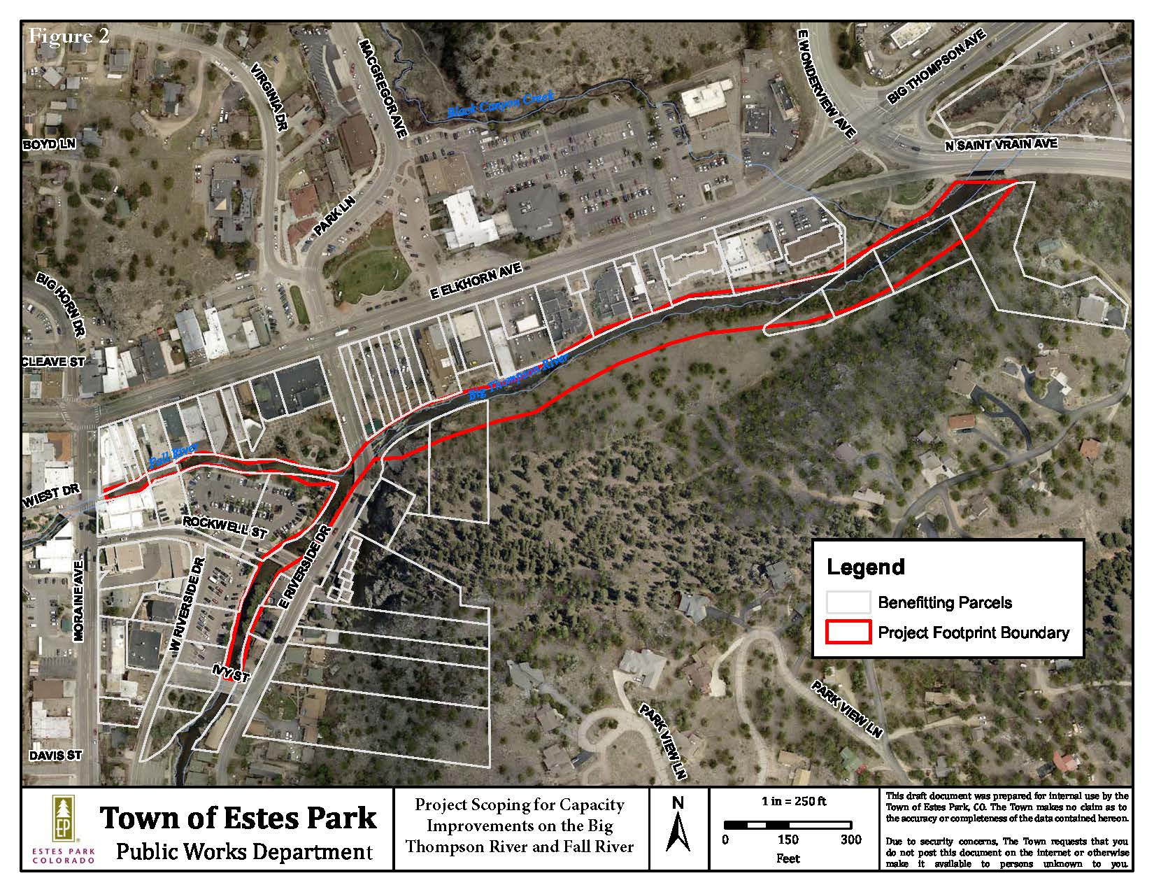
Potential capacity improvements for flood mitigation near the confluence of Big Thompson and Fall Rivers
The Town of Estes Park’s Public Works Department and its consultant have completed a study on how potential changes to the depth or width of rivers could increase capacity and contribute to better flood control in downtown Estes Park. These changes, along with the potential for new bridges at Rockwell Street and East Riverside Drive, would help reduce the risk of flood damage to buildings in the downtown corridor near the confluence of the Big Thompson and Fall Rivers.
Community members were invited to contribute ideas for the outcomes at a presentation and forum held on May 1, 2024. Further community input was invited during a second public meeting that took place on June 12, 2024. Both meetings were streamed live and are available for on-demand viewing. Links to the consultant presentations and other project resources are available under the Scoping Project tab on this webpage.
For more information, contact Jennifer Waters, Floodplain Administrator, at jwaters@estes.org or 970-577-3740.
- Public Meeting News Release - May 1, 2024
- Project Footprint Boundary Map
- Presentation - May 1, 2024
- Public Meeting News Release - June 12, 2024
- Presentation - June 12, 2024
- Presentation for Town Board Study Session - September 10, 2024
- Presentation for Town Board Study Session - January 28, 2025
- Basis of Design Report - April 20, 2025
After the 2013 Northern Colorado flood, the Colorado Hazard Mapping Program (CHAMP) was established by the Colorado Water Conservation Board (CWCB) to rework the region’s floodplain data and maps. In 2019, draft results for Estes Park were released by CWCB. The Federal Emergency Management Agency (FEMA) referenced this work to produce Preliminary Flood Insurance Rate Maps (FIRMs) and an updated Flood Insurance Study (FIS) in early 2021. A virtual public meeting about the Estes Park maps and the FEMA map adoption process was held on April 1, 2021. Complex multi-jurisdictional flood hazard issues in other areas of Larimer County were resolved, resulting in reissuance of the FEMA maps in December 2021 and October 2023.
FEMA is still in the process of making final changes to the FIRMs and FIS. Final maps are expected to be adopted and effective in 2025.
To review the most recent presentation to the Town Board regarding the status of the floodplain map adoption process, see the Town Board Study Session Presentation: FEMA Flood Map Update held on August 8, 2023.
To view the preliminary FIRMs and FIS, visit the FEMA Map Service Center. To research any Colorado property’s location on the CWCB floodplain map, visit the Colorado Hazard Mapping & Risk MAP Portal and select “Flood Hazard” to enter an address and generate a report. Maps and information are also available in Public Works at Town Hall.
For more information, residents of Estes Park may contact the Floodplain Administrator at 970-577-3740 or floodplainmgmt@estes.org; residents of unincorporated Larimer County may call 970-498-5732 or email Eng-Floodplain@larimer.org.
Flood Risk Fact Sheet - FEMA/NFIP/CWCB
ASFPM Reduce Flood Risk webpage - an interactive flood mitigation resource library
Larimer County floodplains information webpage (unincorporated properties impacted)
Colorado Hazard Mapping & Risk MAP Portal
Adoption of Flood Insurance Rate Maps by Participating Communities (FEMA 495)
The Flood Insurance Rate Map (FIRM) shows the Special Flood Hazard Area (SFHA). This area consists of the floodway and the flood fringe; together, they represent the area likely to be inundated by the 100-year (1 percent) annual chance storm event. Even though your property may not be in the SFHA, you may still be subject to flooding and are eligible for flood insurance.
To review the recently released preliminary map revisions from FEMA, visit the Larimer County website or the Colorado Hazard Mapping & Risk MAP Portal. For questions and information on navigating the maps, please contact the Town's Floodplain Administrator, Jennifer Waters, at 970-577-3740 or floodplainmgmt@estes.org.
The Town has four major drainage basins with mapped floodplains. Since the 2013 flood event, FEMA Flood Insurance Rate Maps (FIRM) may no longer accurately reflect flood risk in Estes Park. The Town of Estes Park is now regulating to the hydrology studies completed in 2014 and 2017, and the floodplain regulations revised in 2019.
Floodplain management is a service of the Town to inform, educate and assist property owners in reducing flood damage. This includes regulatory, mitigation and resiliency efforts. Regulatory includes mapping, zoning, building requirements and more.
View the Town's webpage dedicated to spring runoff resources affecting Estes Park.
View the Town's floodplains regulations in the Estes Park Municipal Code Title 18 - Floodplain Regulations.
A Floodplain Development Permit (FDP) issued by the Town may be required for work in the SFHA.
Floodplain Development Permit Application
Note: Only engineers registered in the state of Colorado can apply for Floodplain Development Permits on behalf of the property owner.
For additional information concerning work in the floodplain, please contact the Town's Floodplain Manager at 970-577-3740 or floodplainmgmt@estes.org.
An important element in floodplain management is the National Flood Insurance Program (NFIP). Established by Congress through the National Flood Insurance Act of 1968, the NFIP is operated under the jurisdiction of FEMA. This federal program enables property owners to purchase flood insurance. By participating in the NFIP, flood insurance is available to local property owners. Any owner or renter in the Town of Estes Park may purchase flood insurance through the NFIP.
Estes Park joined the NFIP in the early 1970s, and since that time the Town has been active in floodplain management. The goals of the program are to:
- Reduce flood hazards
- Regulate floodplain activities
- Educate the public about flood risk and floodplain management
The National Flood Insurance Program (NFIP) was reauthorized effective October 1, 2025. NFIP’s last long-term reauthorization was in 2012 with the Biggert-Waters Flood Insurance Reform Act. Since the end of 2017, there have been 34 short-term reauthorizations. As of August 31, 2025, there are 128 NFIP Policies in force in the Town of Estes Park.